Marine Minerals
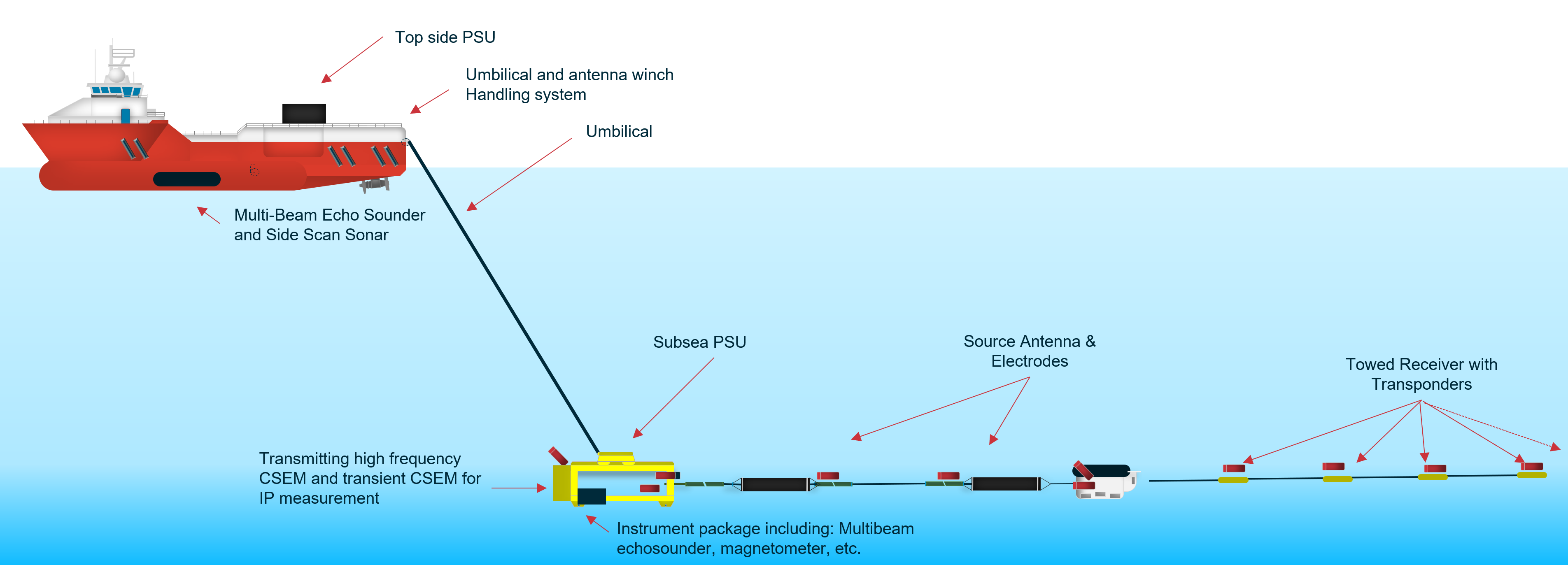
EM methods are widely used in the mining industry and are expected to play a leading role in the emerging marine mineral exploration industry. EMGS is currently developing a commercial CSEM system for marine minerals mapping.
According to the International Energy Agency (IEA), the energy transition will require a significant increase in metallic mineral supply to upscale the electricity infrastructure, the production of battery capacity and manufacturing of solar panels and wind turbines. The demand for metallic minerals is forecasted by IEA to multiply by more than 6 times on the way to “net zero 2050”. Most of the current metallic mineral supply is from onshore paleo volcanic geological settings. The high-grade deposits are becoming depleted, and new sources of minerals are needed to support the Energy Transition.
Black and white smokers building up as Seabed Massive Sulfide (SMS) deposits along modern day ocean spreading and back arc ridges are rich in copper, zinc and to a lesser extent rare earth minerals. The current active smokers have a thriving pristine ecosystem which should be protected from human interference. However, SMS deposited by present-day extinct smokers are being considered as potential supply sources for minerals by governments.
The SMS deposits discovered to date are at the seabed in ultra-deep water. The width of a typical exploration target is in the order of hundreds of meters, making it relatively small compared to the vast ocean bottom areas in question. Moreover, only a few of the many “extinct” SMS deposits are expected to have metallic minerals in large enough concentrations to be of commercial interest for deep-sea mining. Hence geophysical techniques are needed to cost-effectively search for and identify potential SMS prospects for further testing and eventually exploitation.
Our feasibility studies show that our cutting-edge EM technology has the potential to become one of the most important tools in the exploration toolbox for marine minerals (in combination with seismic and other acoustic measurements). We are looking to address the mineral exploration challenge at different stages in the exploration process ranging from regional reconnaissance to detailed appraisal of confirmed deposits.
We propose to use our current proprietary CSEM/MT technology to arrive at superior images of the subsurface allowing geoscientist to define areas likely to be plays for marine minerals by understanding the present and past volcanic processes and hence identify areas/plays that have the better potential to contain SMS deposits with commercial mineral content.
EMGS has already acquired two EM surveys together with the Norwegian University of Science and Technology (NTNU) to improve the understanding of the magmatic processes that lead to the formation of marine minerals at the spreading ridges.
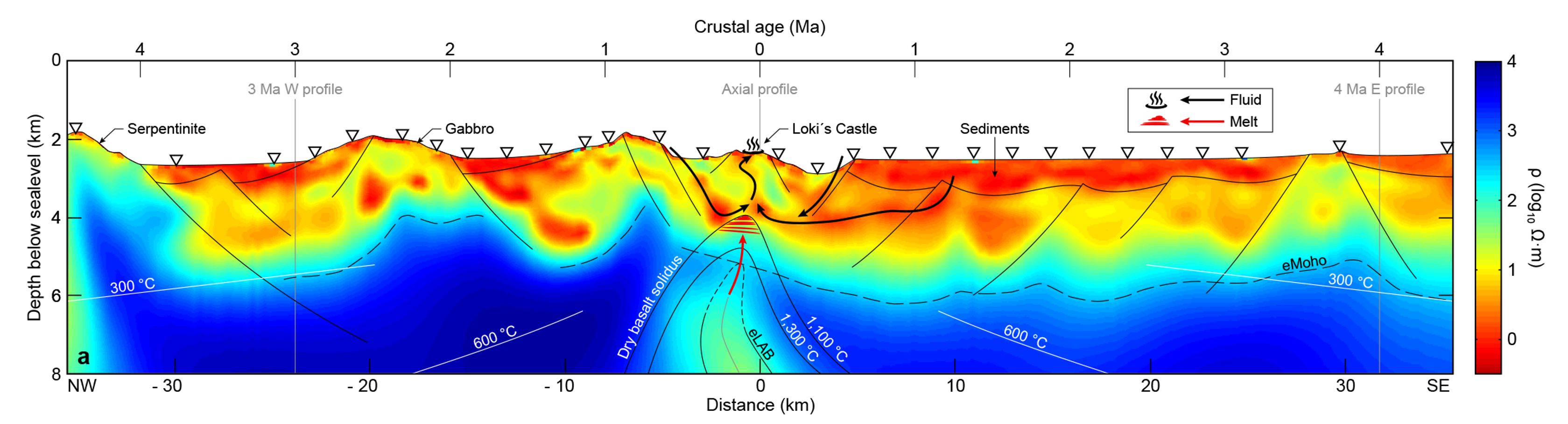
When plays containing a number of possible SMS deposits are identified the next step is to estimate which SMS leads are likely to contain commercially interesting quantities of metallic minerals. Work by Geomar (Gehrman et al, Marine Mineral Exploration with Controlled Source Electromagnetics at the TAG Hydrothermal Field, 26◦NMid-Atlantic Ridge, Geophysical Research Letters 2019) has demonstrated that the combined analysis of magnetic susceptibility-electrical conductivity and chargeability allows the discrimination of primarily iron rich SMS deposits from SMS deposits with higher content of valuable metallic minerals.